Australia So Much to See


Most people travelling around Australia will not be taking four wheel drive treks such as the Anne Beadell Highway, which requires
a number of permits. Remote inland routes such as this require pre planning and early application for a number of permits as
these may take several weeks. These include permits to travel through Aboriginal lands, a desert parks pass, a pass to travel
through the Mamungari Conservation Park (formerly known as Unnamed Conservation Park) and a defence force permit to go through Emu
Junction area.
For information on how to apply for permits to travel through Maralinga Tjautja Lands and the Woomera Prohibited
Area click here
The Anne Beadell Highway runs through Great Victoria Desert. Surveyed in the early 1950's by Len Beadell for the British/Australian
atomic testing, the fascinating story can be read in Len’s book “Blast the Bush”.
Len Beadell books and DVDs
Beadell Tours
Tag along tours are conducted through the regions that Len Beadell surveyed and constructed with his road crew.
See Beadell Tours
Surveyor Len Beadell has a special place in the hearts of Australians who love the outback and deserts of South, Central andWestern Australia. He not only surveyed roads through unknown deserts during the late 1950s and 1960s, but was an accomplished
author, cartoonist and public speaker. He also had many other skills, including being an emergency dentist to his road building
crew.

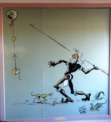
Len Beadell's cartoon on the opening of the weather station at Giles is on display at the weather station. Typical of Len's
cartoons, with a lizard in the picture.
Len's Roads
The following map from the display at Giles weather station shows the huge area where Len Beadell and his team surveyed
and built roads mostly during the 1960s. All but one of these roads through the western and central desert areas of Australia
can still be travelled by adventure travellers, and perhaps that one by the most adventurous.
This map has been taken from the final one of Len Beadell's books about his road building days, and shows the Western Australian road.
Only the northernmost road, from Well 35 to Callawa Homestead, has become obscure.
Len's books are entertaining and informative, and a must to read them when travelling in the country he surveyed. See a
precis of his books here.
Use your browser back button to return to the page you were reading
Copyright (C) 2013 AustraliaSoMuchtoSee.com. All rights reserved


