Australia So Much to See


Short version only - full version with pictures yet to come
We reach Tasmania and follow a plan to see a good cross section of the island in our short seven week visit, starting in the North.
We then explored the West, the South, the East, travelled through the historic Midlands and finally toured through the Central
Highlands. See where we camped.
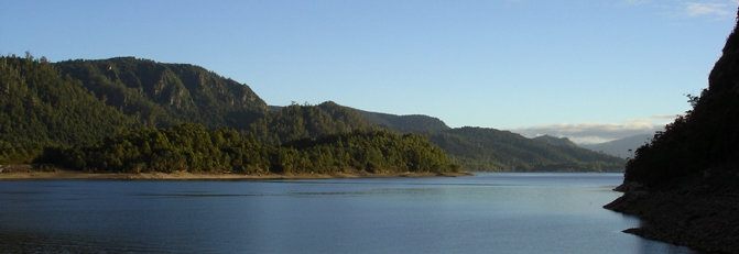
Preminghana
We visited the Preminghana Aboriginal land, named after the Aboriginal name for the hill now known as Mount Cameron
West. Since the 524 hectare site became an indigenous protected area in 1999, re-vegetation and control of weeds such as gorse
has been successfully undertaken.
From here we looked north to the Cape Grim Peninsula at Woolnorth, and the wind farm
on the Cape.
We spent some time talking to the Preminghana caretakers who live on site, and who welcomed our visit.
From further south we looked across dairy farms to Mount Cameron West, which is part of Preminghana land. The hill
cannot be accessed by tourists. It was on an attempt to reach this dominating hill that we found ourselves at Preminghana.
Two visits to Arthur River and a bridge with holes in it, plus a drive through the Southern Arthur Forests
A little way inland,
we drove around forestry tracks away from the main roads and found much of the forest has been clear felled and replaced with pine
and blue gum plantations. Considering the beauty of the variety of natural timbers that occurred, their loss is a shame.
The Bridge over the Arthur River looking north, with plywood covering the holes. That day, a vehicle had broken through
the decking and the hole was covered with a similar plywood sheet.
In the Southern Arthur Forests, the Milkshakes Reserve is
a small patch of dense and tall forest, surrounded by low scrub and button grass. Vibrant green fern covered the stem of a large
tree fern in this lush patch of forest.
A walk through and out of the forest brought us out to a limestone hill which
after climbing gave extensive views across forests and grasslands. Near the top, we met yet another tiger snake.
The Rapid River has
an old wooden bridge laid on logs. It doesn’t look very secure, but traffic crossed safely.
The Chisholm Forest contains
numerous sink holes. These have clear still water. We visited Lake Chisholm, and passed some very tall trees along the
walk trail.
From a vantage point we glimpsed the Arthur River down in a valley, then drove further on to where a bridge crossed
the river. With our caravan parked at Black River estuary near Port Latta, we headed west towards the coast to continue the
loop drive.
We passed the turn off to the alluring Western Explorer route, as we did not have time to fit this trek into
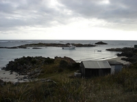
our timeframe. We met the west coast at a tiny fishing shack settlement Couta Rocks. Fishing boats were moored in natural
harbours amongst the rocks against a stormy west coast sky.
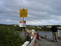
It had proved to be a long day touring the Southern Arthur Forest. Dusk was approaching when we reached the Arthur River Bridge for our second time, to find that since our first visit some weeks ago,
repairs had commenced and the bridge was closed to all traffic.
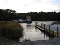
Our fears were allayed when we saw a sign pointed to a small
ferry landing, from where we were taken across the river on a small cargo ferry. We would not have been able to cross if we
had the caravan with us. Thanks to the ferry and the fact that we were not too late for the last crossing if the day, we were
able to return to our caravan at Black River.
The signage “Beware of Gaps on Bridge Deck” took on a whole new meaning.
With only the degraded decking replaced and a rails spruced up with fresh paint, this narrow bridge remains otherwise as
is.
The South West
Heading south we met the Murchison Highway near the turn off to Waratah, where Mount Bischoff was once the richest
tin mine in the world. The remnant of the mountain was obscured by low cloud as rain moved in on us. In this former mining
town, small pressed tin mines houses are now painted in bright colours by new owners.
We crossed the Mackintosh River as the rain slowed, and moisture oozed up out of the hills.
After sharing the parking area at
the wall of the Mackintosh Dam with caravanners from New Zealand, next morning was clear and beautiful. We visited nearby Murchison
Dam, from where water is taken two kilometres by tunnel into Mackintosh for the power station.
Montezuma Falls, at 104
metres, are the highest falls in Tasmania were on our ‘must see’ list. I asked a local lady in the street at Roseberry about
access to the falls, as I knew there was a four wheel drive adventurers track into the falls, but not suitable for us as we were towing
the caravan. She said there is no road access to the falls, and directed us to the walk saying you turn off the road and drive
past the cemetery and not far is a parking area. Yes, we would be able to take the caravan. She added that there was a
walk to the falls. How far? Not far. We should have known when track in to the falls was rather more than ‘not far’. The five kilometre walk into Montezuma Falls follows the tram track, once used by a small rail train to take workers into the dense
and boggy rain forest to cut timber for the mines. It is flat, but slippery in wet patches.
A
disused bridge has been taken over by ferns and other rainforest vegetation. Delicate flowers can be found amongst the ferns
and rains forest. The whole area was damp, with water oozing across the pathway and into the river tinkling below. Working
conditions would have been very trying for the early timber cutters who pioneered western Tasmania.
A suspension bridge now crosses
the face of the falls. In an old photo in the Zeehan museum, a train can be seen passing in front of the falls where the suspension
bridge now crosses the ravine. Update: In 2020 the suspension bridge is closed for safety, and was re-opened in November 2021.
We
headed towards Corinna where the Fatman ferry which our daughter used to take across the Pieman River completes the route for those
following the Western Explorer. With our caravan, we were too long to fit on the Fatman, but we met other caravanners who had
just come across with their Patrol and 16’ Bushtracker; they had only just fitted on.
Maximums for the Fatman ferry
are: GVM 6.5 tonne. Wheel width 2.13 metres and body width 2.5 metres. Combination wheel base maximum 9 metres.
Caravan underbody clearance .2 metres.
The Museum at Zeehan is well worth taking a whole day to look around. TheZeehan Museum is housed in the former school of mines, and the entire mineral collection is on display, together with other history
of the region. Fascinating Crocoite crystals are found in this region and a ‘cave’ is devoted to displaying Crocoite.
Old trains are on display and being restored at the Zeehan Museum. One has a carriage with angled seats, made to take
workers up the steep mountain rail tracks.
The beautiful theatre adjoining was once the largest theatre in Australia. Taking the whole day, we did not get to see everything in the Museum complex.
Whilst based at Zeehan we went to
Strahan. The town itself was too ‘touristy’ to appeal, but this is the gateway to the Franklin-Gordon and South West National
Park world heritage area. We took the boat trip around the Macquarie Harbour and up into the Gordon River.
Approaching
the heads at Macquarie Harbour, which encloses an area of around 250 square kilometres and is the second largest harbour in the southern
hemisphere, but its narrow 120 metre wide dangerous entrance limits the size of boats which can enter.
Feeding the fish
– fish farming in the Macquarie Harbour.
The boat tour takes a visit to Sarah Island, where second offender convicts were incarcerated. There was once a ship building yard on the island, utilising the convict labour and readily available Huon Pine; the best timber for
ship building due to its durability and natural oil, making it resistant to water penetration. Although extremely slow
growing, the trees can attain heights of over forty metres and reach ages in excess of 2,000 years, making them among the longest-lived
organism on Earth. International headlines were made with the discovery of a stand of Huon Pines on Mount Read that were quoted as
being in excess of 10,000 years of age. Huon Pines may no longer be cut, but cut logs are still available and milling is demonstrated
in Strahan. The Pine has a fresh aroma.
Heading up the Gordon River, where the average rainfall is 4.5 metres per
annum. Dense rain forest grows on a constantly wet forest floor.
While we were in Tasmania, the Ulysses bikers held
their annual rally. With 5,000 bikes, many riders took the opportunity to tour the island. We camped next to this three
wheeled machine with folding camper trailer. The rider appeared to have some mobility difficulties.
Next we
visited Queenstown, with the famous denuded bare hills behind the town.
The restored authentic steam train trip from Queenstown
to Strahan is in part on an ABT rack railway system, which allows the train to climb a gradient of 1 in 16 then descend on a 1 in
20 gradient (or the other way on the return journey). The engine used 2,000 litres of water to climb the Rinadeena Hill. At places the track was so narrow that tress brushed past us.
Good news: The ABT Railway reopened on 6 January 2014 after
ten months of undergoing mainenance on this iconic track, only going from Queenstown over the range and down Rinadeena Hill to
Dubbil Barril and returning. On 15 December 2014 the the rest of the track to Strahan was re-opened, with trips half
way from either direction, in addition to a full trip from Strahan to Queenstown and return. See details
With glimpses
of at first the Queen then the King Rivers, we could see just how the mining practices of the early years have contaminated the water
and surrounding soils. No aquatic life can exist in these rivers.
After leaving the bare hills of the Queenstown surrounds,
we stopped for lunch at Lake Burbury, before continuing east to the centre of the island to reach the only road access deep into the
world heritage area, to Lake Pedder, Lake Gordon and the Gordon River Dam.
Lake Pedder and the Gordon River Dam
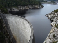
Looking down on the 140 metre high curved and wedge shaped wall of the Lake Gordon dam,
it looked so small way down at the bottom of a stairway of 194 steps. It was well worth the walk to cross the wall of this famous
dam.
Lake Gordon has a surface area of 272 square kilometres and total volume of 11.9 cubic kilometres. Lake Pedder has
a surface area of 242 square kilometres and a total volume of 3.3 cubic kilometres.
This scheme has created the largest water
storage in Australia. But for the public outcry, much more of the wilderness area would have been flooded to make a massive
dam. What has been saved created the world famous tourist attractions of the Franklin-Gordon Wilderness.
Strathgordon
was the town created during the construction of the Gordon River dam, and now has accommodation for tourists.
The water
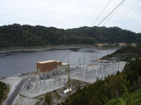
levels at Lake Pedder are maintained at the expense of Lake Gordon which was well below capacity. Fallen timber lines the exposed
edges. The Lake Gordon power station is underground way beneath these transformers, and water discharges back into the Gordon River.
We
camped on the shoreline of beautiful Lake Pedder. After dark, another camper spotted a small quoll.
Next morning
the lake was a different shade, but just as lovely.
We continued our journey through the south east, to the southern tip
Copyright (C) 2013 AustraliaSoMuchtoSee.com. All rights reserved


