Australia So Much to See


Copyright (C) 2013 AustraliaSoMuchtoSee.com. All reights reserved
< Previous
Next page >
Home
Travelogues
Tips and Hints
Lists and Links
Q & A
Contact
< Previous
Next page >
Home
Travelogues
Tips and Hints
Lists and Links
Q & A
Contact
Home > Travelogues > 2019 Travelogues Index  - The Mirackina Range and Coober Pedy to William Creek
Want to know more?
Contact Us
Back to Top ^

The Mirackina Range

341_mirackina_range_img_2887a.jpg 341_steer_around_us_img_2881.jpg 341_mirackina_range_img_2866.jpg 341_mirackina_range_img_2875s.jpg 341_mirackina_range_img_2865.jpg 341_mirackina_range_img_2860a.jpg 341_mirackina_range_img_2864.jpg

Much of the road from the station to and through the Painted Desert was quite corrugated.  This and the thought of taking our caravan to Oodnadatta and the Oodnadatta Track to William Creek seemed daunting, and we had a close deadline for our Lake Eyre flight booking. Decisions to be made. 


Shall we go east to Oodnadatta and follow the Oodnadatta track south to William Creek, or go south to Coober Pedy on what we know is a good road?  The latter is shorter and easier, and a safer alternative to get us to William Creek on time for our Lake Eyre flight booking.  So as we left the station still undecided, as good trip plans go, we turned - - - - west.
 

A spur of the moment decision and a lovely scenic drive.


This road was a pleasant surprise, as we soon met the breakaway hills of the Mirackina Range.  This is part of the same system as Arckaringa Range, which incorporates the Painted Desert.  While not the same colourful hills as the Painted Desert, winding through these ranges for around forty to fifty kilometres was a delightful drive.  The road was in good condition too. 


Above left as we enter the range, and above right looking back from the same spot. 
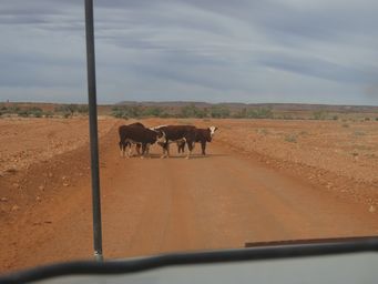


We encountered a group of Hereford steers engaged in a bit of one-upmanship blocking our way. 

“Steer around us.”  But as the road was blocked, we stopped while they sorted out their bullying order, then they wandered down the road ahead of us for some way before they turned off and allowed us a free passage. 

Joining the Stuart Highway just south of Cadney Homestead Roadhouse (Cadney Park), we followed the Stuart Highway south to Coober Pedy. 


Our lunch stop was at a rest area down an unsealed track taking us well back from the highway.  Known as Mathesons Bore, this would make a quiet overnight stop away from the Highway.  There is a picnic table and a tank with non-potable water. 


This picnic and rest area is on the west side of the Stuart Highway, forty kilometres south of CadneyPark Roadhouse.

From Coober Pedy we continued to William Creek.  The unsealed road was in fair order, with corrugations not severe. 
 

Lake Cadibarrawarracanna is a relatively large usually dry salt lake a little to the north of the road to William Creek, but not visible. Nor is this lake readily accessible.  There is a 6.5 kilometre four-wheel drive public access track through Anna Creek Station for those wanting to make the trek to the location, often said to have the # longest name in Australia.  Anna Creek Station allow camping where the public access track finishes.  This is on the southernmost creek entering the lake around one kilometre prior to the lake basin itself, and there may be water here in this wide creek. 

 
341_to_william_creek_img_2913.jpg 341_to_william_creek_img_2911.jpg
The photo below right was the most corrugated section, and this was nearer William Creek end of the road. After spending a night along the way, we reached William Creek as planned, the afternoon of the day before our flight booking. 

Lake Cadibarrawirracanna, meaning the stars were dancing, is said to be the second longest official place name in Australia.


A South Australian government source describes the lake as having a length of 32 kilometres a width of 9.7 kilometres and an area of 220 square kilometres. 

Extracts from Wikipedia

# Lake Cadibarrawarracanna is in fact the second longest single word official place name in Australia, being surpassed by a hill known as Mamungkukumpurangkuntjunya which is also in outback South Australia, 110 kilometres west of Marla. 

Heading for William Creek

Continue reading >
Mathesons Bore